

easyAIS

easyAIS介绍
“easyAIS” is a free AIS real-time vessel positioning tool designed for the use on AIS receivers with WiFi connectifity.
The Automatic Identification System (AIS) is a maritime transponder/receiver system defined by the IMO (International Maritime Organisation).
AIS main objectives are to improve maritime safety and to protect the maritime environment.
Practically, AIS
•assists collision avoidance (AIS ship-to-ship)
•enables ports and coastal states to identify ships and to manage and supervise the traffic in their waters (AIS Coast station, VTS)
•helps to resolve the difficulty of identifying ships when not in sight (e.g. at night, in radar blind arcs or shadows or at distance)
By means of special VHF transceiver cruise data will be exchanged in short terms automatically. The treatment has a worldwide standard and runs every where. So vessels who use AIS devices from different companies will „see“ each other.
AIS enables to view over obstacles and complements radar. Acording to the antenna instalation hight an AIS station has got a transmission range about 20 to 30 nautical miles.
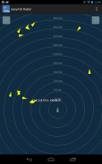
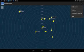
With the “easyAIS” app by the Weatherdock AG, all AIS targets within range are displayed relative to the user's position.
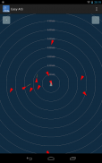
Main screen after starting the app is a virtual radar screen showing the AIS targets in relative position to you
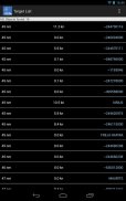
Just tapping the screen on an AIS target brings you to a list with all transmitted details of this target, e.g. GPS position, corse over ground, speed over ground, ship name, call sign, length, width, draft, port of registration …
“easyAIS” works by getting AIS data via WiFi from the AIS receiver or transceiver aboard. Without a running AIS
Notice:
“easyAIS” should not be used for navigational purposes!“easyAIS”是一个免费的实时AIS船舶定位工具的使用AIS接收器与WiFi connectifity设计。
自动识别系统(AIS)是一个海洋的转发器/接收器系统定义的IMO(国际海事组织)。
AIS的主要目标是改善海上安全和保护海洋环境。
实际上,AIS
•协助避免碰撞(AIS舰对舰)
•使港口和沿海国家确定的船舶和在其水域的交通管理和监督(AIS海岸电台,VTS)
•帮助解决困难的识别船舶不在视线时,(例如,在晚上,在雷达盲区的弧或阴影或在距离)
通过特别VHF收发器巡航数据将在短期内自动进行交换。治疗有一个全球的标准和运行的每一个地方。因此,从不同的公司使用AIS设备的船舶将“看到”对方。
AIS可以查看越过障碍,并补充了雷达。该院到天线安装目录HIGHT一个AIS站已得到了约20至30海里的传输范围。
随着“easyAIS”应用程序的Weatherdock AG,显示范围内的所有AIS目标相对于用户的位置。
启动应用程序后,主屏幕是一个虚拟的雷达屏幕上显示的AIS目标的相对位置
只要点击屏幕上的AIS目标带给你一个列表,这一目标传输的所有细节,如GPS位置,科西嘉(Corse)对地,对地,船名速度,请致电标志,长度,宽度,吃水,船籍港...
“easyAIS”的作品,获得AIS数据通过无线网络从船上AIS接收器或收发器。如果没有正在运行的AIS
注意:
“easyAIS”不应该被用于导航目的!


